If you are a global wanderer like us, you have probably asked yourself many perplexing questions like what is the difference between “cay” and “key” or how do we know how old Earth is. Plus, many things we sailors take for granted like lat/long, have a long history before being established that we find intriguing. We’ve gathered answers to a few of the big questions we have had and hope you enjoy.
What is Prime Meridian?
A meridian is a human-established line based on circular degrees on a map that goes from north to south dissecting Earth into 360 meridians. These lines are also known as longitude. The prime meridian is the beginning point for all other meridians serving as the zero reference point for all astronomical observations. It is at a longitude of 0° so it serves as a boundary line for the eastern and western hemispheres with 180 negative-valued meridians to the west and 180 positive-valued meridians to the east.
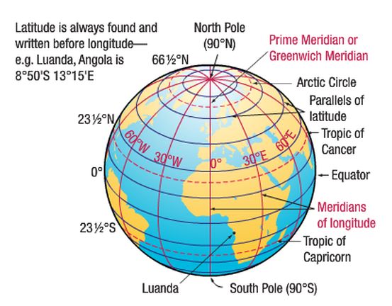
The implementation of the prime meridian in Greenwich, England, in 1884 unified the globe in its time and space measurements, resulting in all maps being drawn according to the prime meridian’s longitudinal location.
How did the Prime Meridian become “line zero”? In the 19th century as Europeans took to the seas to explore, conquer, and trade with other countries, the need for accurate astronomical information for navigation, development of cartography, and global timekeeping was needed. It was clear that a way of establishing longitude was necessary. The decaying Greenwich Castle in Britain was selected to establish a Royal Observatory for aiding maritime operations.
Then in 1884 as creation of longitudinal maps was to be the global method of achieving cartography and time measurements, the Prime Meridian was defined using the position of the large ‘Transit Circle’ telescope in the Royal Observatory. The transit circle was built by the 7th Astronomer Royal, Sir George Biddell Airy, in 1850. The cross-hairs in the Transit Circle’s eyepiece defined Longitude 0° for the entire world.
Constituents determining the position of the vital longitude 0º in the late 1800s argued Greenwich would be the most advantageous to the the most people because:
- the US had already chosen Greenwich to base its national time zone system
- at that time in history, almost 3/4 of commerce relied on sea-charts that used Greenwich as the Prime Meridian.
What Is the Tropic of Cancer?
Now that we have the longitudes all figured out, let’s explore the latitudes or parallel lines that run from east to west on maps across the world.
Just like the equator, the Tropic of Cancer is an east-west latitudinal line. There are 5 major parallels from north to south:
- Arctic Circle
- Tropic of Cancer
- Equator
- Tropic of Capricorn
- Antarctic Circle.
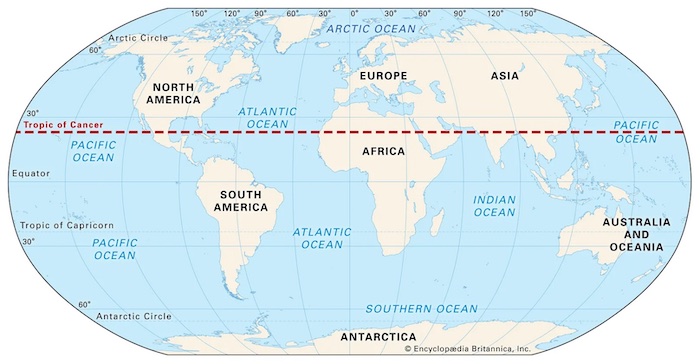
The “tropic” lines are defined based on the sun’s geographical relationship to Earth. The Tropic of Cancer is the northernmost point where the sun is directly overhead at high noon during the northern hemisphere’s summer solstice in June. The Tropic of Capricorn is where the sun is directly overhead during winter solstice in December. The Tropic lines are located 23.5° north and south of the equator.
How Was the International Date Line (IDL) Established?
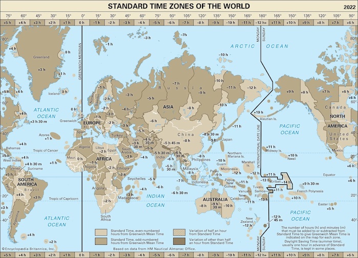 Located on the other side of the planet from Prime Meridian, the IDL
roughly follows the 180° meridian. The IDL is one of the most important meridians because of its establishment of global time zones, yet it is almost entirely located in the ocean where few inhabitants live. But if you do live on or near the IDL, you can literally time-travel as you cross the imaginary line, you can add or subtract 24 hours for the date where you are.
As important as the IDL is, it has no legal status so countries may choose which side they are on, which is why the IDL does not perfectly follow the 180° longitude. Rather the IDL zigzags, most notably at the equator where the IDL jogs east to encompass Kiribati then returns to the 180° as it passes through the Samoan islands.
What Is the Difference Between an Ocean and a Sea?
The words “ocean” and “sea” are used interchangeably by most of us. But geographers use the 2 terms quite specifically:
- oceans are the large bodies of water that cover most of Earth
- seas are smaller bodies of water that are on the margins of the ocean and partially enclosed by land.
Think of the the Atlantic Ocean’s Mediterranean Sea defined by the southern European countries and northern African countries. Or of the Pacific Ocean’s Bering Sea located between the Alaska and Russia.
The only exception is that the North Atlantic’s Sargasso Sea that is not near land rather defined only by ocean currents. Its boundaries fluctuate based on the Gulf Stream to the west, the North Atlantic Current to the north, the Canary Current to the east, and the North Atlantic Equatorial Current to the south. The Sargasso Sea’s dynamic boundaries roughly correlate with the Azores High Pressure Center.
Do Oceans Have Specific Boundaries?
Though humankind has divided it into sub-oceans, only one ocean scientists refer to as the “world ocean” exists. Mapmakers and governments found it useful to divide the massive ocean into smaller bodies: Atlantic, Pacific, Arctic, and Indian Oceans. The ocean surrounding Antarctica has in recent times been called the Southern Ocean.
But there is no way to tell when you cross form ocean into another as it is one endless body of water. But, there is an exception that is surprisingly the last ocean to be named. The Southern Ocean is bounded by a strong current that surrounds its incredibly frigid waters making it easier to know where this sub-ocean begins and ends.
What Is the Deepest Point in the Ocean?
The deepest point in the ocean is called the Challenger Deep named for the British Royal Navy survey ship HMS Challenger used in the 1872–1876 expedition that first recorded this seabed’s astounding depth. This deepest point on Earth is 35,768 to 35,856 feet deep (10,902 to 10,929 meters), almost 7 miles deep.
You may recall in school that you learned that the Mariana Trench is the deepest area on Earth. And this remains correct. But the Mariana Trench runs several hundred miles beneath the western Pacific Ocean. Challenger Deep is in the southern end of the Mariana Trench that is southwest of Guam.
The explorers aboard the HMS Challenger used sounding rope to calculate the trench’s depth to be 26,850 feet in 1875. In later years, advanced sonar techniques were used to measure its current recorded depth. Though this abyss has had varying measurements in its history, it remains the deepest known place on Earth, but with most of the world’s oceans unexplored, we may yet discover a deeper crevasse.
More intriguing than the depth itself is that the Challenger Deep is three times deeper than the average ocean floor depth.
How Old Is Earth and How Do We Know?
Scientists have yet to discover the exact age of our planet and may never, but they currently quantify the Earth to be about 4.54 billion years old, plus or minus 50 million years. Among advanced technologies, radiometric dating is the primary way that researchers use today to determine the age of rocks which helps them extrapolate Earth’s age.
Earth’s oldest rock specimens have been found in Canada and are 4.03 billion years old. Other locations such as Greenland, Australia, and Swaziland have rocks that are 3.4 to 3.8 billion years old. But Earth is still quite young in the grand scheme of the universed as stardust discovered on Earth is 7 billion years old.
How Is a Cay Different Than a Key?
Ever wondered if there is a difference between Key Largo in southern Florida and Ambergris Cay in Turks and Caicos? The short answer: No difference.
The geographical terms “cay” and “key”, both pronounced “kee” are a bit like the pronunciations of “data” (day-tuh vs. dah-tuh) or “pecan” (pee-can vs. peh-cahn). The term selected for use depends on the region.
Both “key” and “cay” originate from the Spanish word (which is also a Taino word) “cayo”, which translates to “small island”. The terms we used today are interchange and refer to a naturally occurring low-lying island, sandbar, or coral reef in a tropical locale, most often the Caribbean.
The British Virgin Islands boasts many keys and cays but is the only place that the two workds are used to describe one place, Key Cay. It may have gotten its name at the same time the bay in teh area was named Key Bay.
Never been? Look for it next time you are in the BVIs. It is a small, rarely visited islet south of the east-west peninusal of Peter Island…on the other side of the island from Little Harbour. It offers undisturbed snorkeling areas and idyllic views of a rocky islnd.
To add to the clarity of maritime words pronounced “kee”, the term “quay” is a pier or platform used for loading and unloading boats, almost always a manmade structure.
Is the Amazon or the Nile Bigger?
Africa’s Nile River runs 4,258 miles through the eastern side of the continent from the mountains of Burundi near Lake Victoria to its delta in Egypt. We all grew up being taught that the Nile was the longest river with the Amazon in South America a close second. But rivers constantly change their courses and seasonal waterflow adds to the difficulty in accurately surveying on length. But one fact is indisputable as the Amazon is a wide river with a massive delta so it has always been the undisputed largest in terms of volume of water.
A 2007 expedition claimed the mighty Amazon flowed 4,225 miles from the Andes of Peru through Bolivia, Venezuela, Colombia, and Ecuador then spilling into the Atlantic Ocean in the northeast corner of Brazil. At the time the Nile was deemed 4,130 long so that meant that the Amazon was not only more water by volume but also the longest. Since then both rivers’ length has be re-measured many times using now-available GPS technology to improve accuracy of the estimates river lengths. And now, it has been settled amongs researchers that the Amazon’s 4,345 miles is longer than the Nile’s 4,258 mile length.
The year 2007 was a big one for the Amazon. Martin Strel swam the river starting February 1st finishing 66 days later on April 7th. This feat broke the record for longest distance swum in one attempt at 3,273 miles, longer than the width of the Atlantic Ocean.
Why Is Australia a Continent and Greenland an Island?
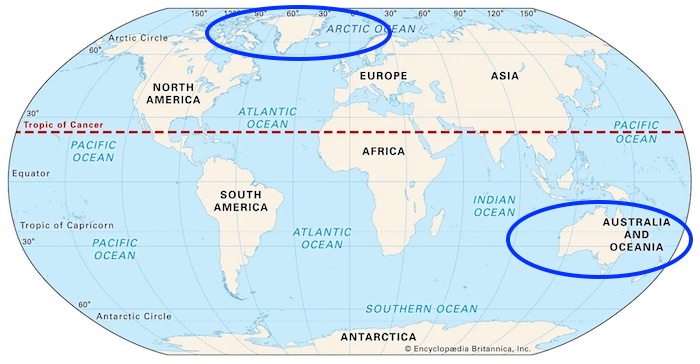 A lot has happened to land masses on Earth since the ancient super-continent, Pangaea, split apart 200 million years ago. The 7 continents that the globe’s Westerners recognize, Africa, Antarctica, Asia, Australia, Europe, North America and South America are a relatively recent phenomenon…culturally and geographically.
During the Jurassic periods when dinosaurs ruled and no humans existed (so no one really cared), North America and Europe were still one land mass. European students are often taught there are six continents combining North and South America into just America. And, have you noticed the 5 rings on the Olympic flag? They point to a five-continent model that combines the Americas and leaves out Antarctica. Some more studious experts believe four is the right model to recognize landmasses naturally separated by water, rather than separated using human-built canals which would be AfroEurasia, America, Antarctica, and Australia).
So you can see the lack of scientific definition makes the distinction between continent and island less than cut-and-dried. But here are the pieces of evidence used to conclude that Australia is a continent and Greenland (the world’s largest island) is an island.
The Earth’s smallest continent, Australia, is roughly 3 million square miles almost 4 times Greenland’s 836,000 square miles. So this large difference in land mass is a good dividing point for setting precedence for what constitutes a continent versus an island.
Also, the “island continent” sits on a tectonic plate that is only partially shared with Asia, while Greenland is on the same tectonic plate as all of North America.
Also, there is a biological distinction in that much of Australia’s plant and animal life is endemic to the country. Much of the flora and fauna of Australia are found nowhere else in the world.
And finally, there is an anthropological distinction. Aboriginal people are inhabit only Australia, while the Inuit, the indigenous Greenlanders, reside throughout the Arctic on 2 continents, North America (Canada and the US) and Asia (Russia).
So separate continents for cultural reasons—together they form a general understanding of what qualifies as a continent.
Of course, there’s also the basic matter of size. Australia is nearly
Altogether, these facts led geographers to classify Australia as a continent, although it is technically an island as well.
What are Your Big Questions?
Let us know what questions keep you up at night (useful when you have night watch duty!) We would love to add to our page here or share on social media.


